Hurricane Erin Disrupts Flights and Cruises as Other Atlantic Disturbances Loom
Hurricane Erin continues to churn through the Atlantic Ocean, creating widespread disruptions in air travel and cruise operations as the storm advances toward the western basin. Airlines and cruise companies are adjusting schedules and routes from now through Wednesday, while meteorologists are monitoring additional disturbance areas that could influence weather patterns in the region.
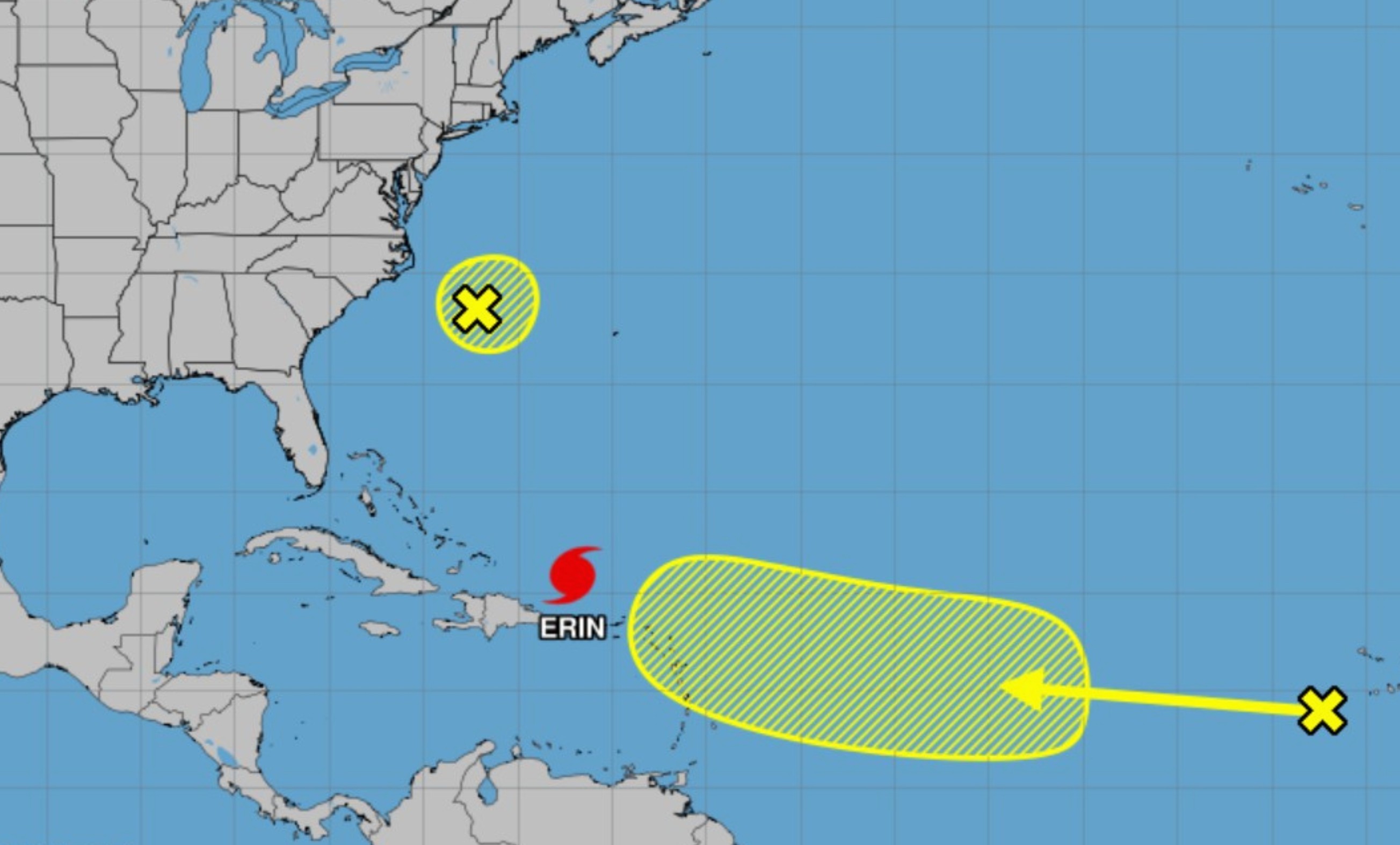
As of Monday morning, Erin is a Category 2 hurricane with sustained winds exceeding 100 mph. Its projected path will keep it offshore but close enough to threaten Caribbean islands, the Bahamas, and potentially the U.S. East Coast later in the week. The National Hurricane Center (NHC) has issued advisories warning of strong surf, rip currents, and the possibility of tropical-storm-force winds reaching parts of Florida by Tuesday night.
Airlines have begun preemptively canceling flights to and from airports in San Juan, Nassau, and Miami, with ripple effects extending to other hubs. Major carriers, including American Airlines and JetBlue, are offering travel waivers for passengers scheduled to fly through affected airports through Wednesday. Flight tracking data shows hundreds of cancellations and delays already recorded since the weekend.
The cruise industry is also being forced to adjust. Ships operated by Royal Caribbean, Carnival, and MSC Cruises have rerouted itineraries away from Erin’s projected path, skipping stops in the Bahamas and diverting toward western Caribbean destinations such as Cozumel and Jamaica. Passengers are being notified of last-minute changes as operators prioritize safety.
Beyond Erin, meteorologists are also watching two additional tropical disturbances in the Atlantic basin. One, located east of the Lesser Antilles, has a medium chance of development into a tropical depression within the next five days. Another, closer to the coast of Africa, shows early signs of organization and could become the next named storm of the season. Both systems are expected to track westward, with long-range models suggesting possible interaction with the Caribbean by late week.
Forecasters emphasize that the Atlantic hurricane season is entering its peak phase, historically the most active period between mid-August and late September. The current pattern of warm sea surface temperatures and low wind shear provides favorable conditions for further storm development. Travelers and residents across the Caribbean and southeastern United States are urged to remain alert and monitor official updates.