Tropical Storm Barry Could Turn into Major Hurricane
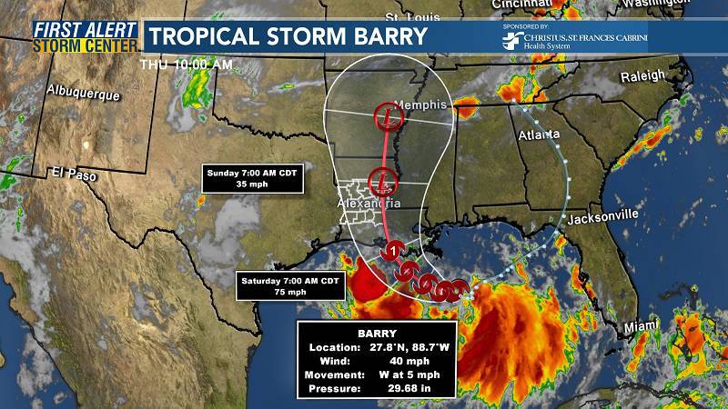
The tropical weather system gathering steam in the Gulf of Mexico was named Tropical Storm Barry on Thursday morning and is predicted to strike Louisiana as a hurricane Saturday.
The storm is forecast to produce up to 20 inches of rain in eastern Louisiana, a storm surge of several feet along the coast and areas of damaging wind. This is a “dangerous” set of conditions, according to the National Hurricane Center.
Louisiana is expected to be hardest hit, especially its eastern half, but coastal and parts of interior western Mississippi will also face serious impacts.
While the slow-moving storm is forecast to make landfall along the coast of eastern or central Louisiana on Saturday, conditions may begin to deteriorate Thursday night, when tropical-storm-force winds could first lash the coast. The core of the heaviest rain and strongest winds should lift through Louisiana and western Mississippi from south to north between Saturday morning and Sunday.
“Flash flooding and river flooding will become increasingly likely, some of which may be significant, especially along and east of the track of the system,” the Hurricane Center writes.
Even before it was named a storm, associated thunderstorms unleashed a deluge that engulfed New Orleans in half a foot of water in two hours Wednesday morning. Through the weekend, it could dump more than three times that amount in parts of Louisiana.
Louisiana Gov. John Bel Edwards declared a state of emergency Wednesday, warning residents that “[t]his is going to be a Louisiana event with coastal flooding and heavy rainfall potentially impacting every part of the state. No one should take this storm lightly.”
Hurricane watches cover nearly all of southern Louisiana, while a tropical storm warning is in effect from the mouth of the Pearl River (near the Louisiana-Mississippi border) to Morgan City (along the south central Louisiana coast).
Storm surge warnings stretch from the mouth of the Atchafalaya River to Shell Beach in southeast Louisiana, while watches flank the warning zone to the west (into central Louisiana) and east (to the Mississippi Alabama Border).
Along the southeast Louisiana coastline, the surge is forecast to push ashore three to six feet of water above normally dry land.
In New Orleans, the storm surge from the Gulf of Mexico up the Mississippi River may elevate the river level to historic heights of around 20 feet, testing levees protecting the city.
The threat posed by rain cannot be overstated. The National Weather Service Weather Prediction Center placed southeast Louisiana, including New Orleans, Baton Rouge and Morgan City, in a rare “high risk” zone for flash flooding.
Areas further east into Mississippi could also see dangerous amounts of rain.
The Hurricane Center predicts 10 to 15 inches of rain near and inland of the central Gulf Coast through early next week, with isolated 20-inch totals in eastern Louisiana and southern Mississippi. Six to 10 inches of rain are predicted in New Orleans on top of the six inches that fell Wednesday.
Too often, people associate a tropical storm or hurricane only with strong winds. In reality, water is the biggest killer, in the form of storm surge and/or heavy rainfall. Most landfalling hurricanes also produce numerous tornadoes in the outer rain bands.
Since 2015, the National Weather Service has produced “Hurricane Threats and Impacts” graphics for every tropical cyclone affecting land, and they include tiered risk assessments from wind, storm surge, heavy rainfall and tornadoes. The set of maps below show where the risks from the various hazards are predicted to be highest:
Although the effects of water from surge and rain will be most widespread, a small zone of damaging winds — including gusts over 80 mph — is likely near the center of the storm which could result in minor structural damage, downed trees and power outages.
Barry is positioned about 95 miles south-southeast of the mouth of the Mississippi and is drifting west at 5 mph. Its maximum sustained winds are 40 mph.
Model forecasts are converging on the storm’s strength and location at landfall, but there is still some wiggle room. The range of track scenarios is from landfall Friday night in eastern Louisiana or later Saturday in central Louisiana. The intensity forecast is somewhat more uncertain, but models mostly predict that Barry will make landfall as a strong tropical storm or Category 1 hurricane.
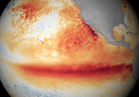
The storm is moving over Gulf of Mexico waters that are much warmer than normal, which may help it attain hurricane strength.
Louisiana is of course no stranger to tropical storms and hurricanes. Just in the past decade, Tropical Storm Lee (2011), Hurricane Isaac (2012), Tropical Storm Cindy (2017), Tropical Storm Harvey (2017) and Hurricane Nate (2017) made landfall in the Pelican State, and Hurricane Katrina’s infamous levee-busting landfall in 2005 is still fresh on people’s minds in New Orleans.
Source: The Washington Post